This post is also available in:  简体中文
简体中文

Crossing the Border
It was hard to know what to expect as we crossed the border into Mexico.
Truth is, the info we’d would come across seemed at odds with itself. So close to the U.S. with millions of tourists traveling there annually, yet the sort of warnings we’ve read ran the gamut from the U.S. Department of State issued Level 4 warning comparing several of the provinces with war-torn countries like Syria, Yemen and Somalia.
On the other hand, there was also no shortage of other overland travelers reporting fantastic experiences on the ground as they traversed through the country in a similar situation as we would be.
Concerns gave way to the logistics, as we approached the small, quiet border crossing between the U.S. town of Presidio and Mexican town of Ojinaga.
The U.S. border came and went with us hardly noticing it. No checkpoints, nobody waving you through. As we progressed through the no-man-zone and entered the Mexican side, the process ended up being as simple as we could have hoped for.
There were no other tourists, so we had the entire office administration to ourselves and 1.5 hours later, we had the temporary import permit for the car, temporary insurance for it as well, and visas for Susan and myself. Everything was set for the journey ahead.
Getting to Copper Canyon
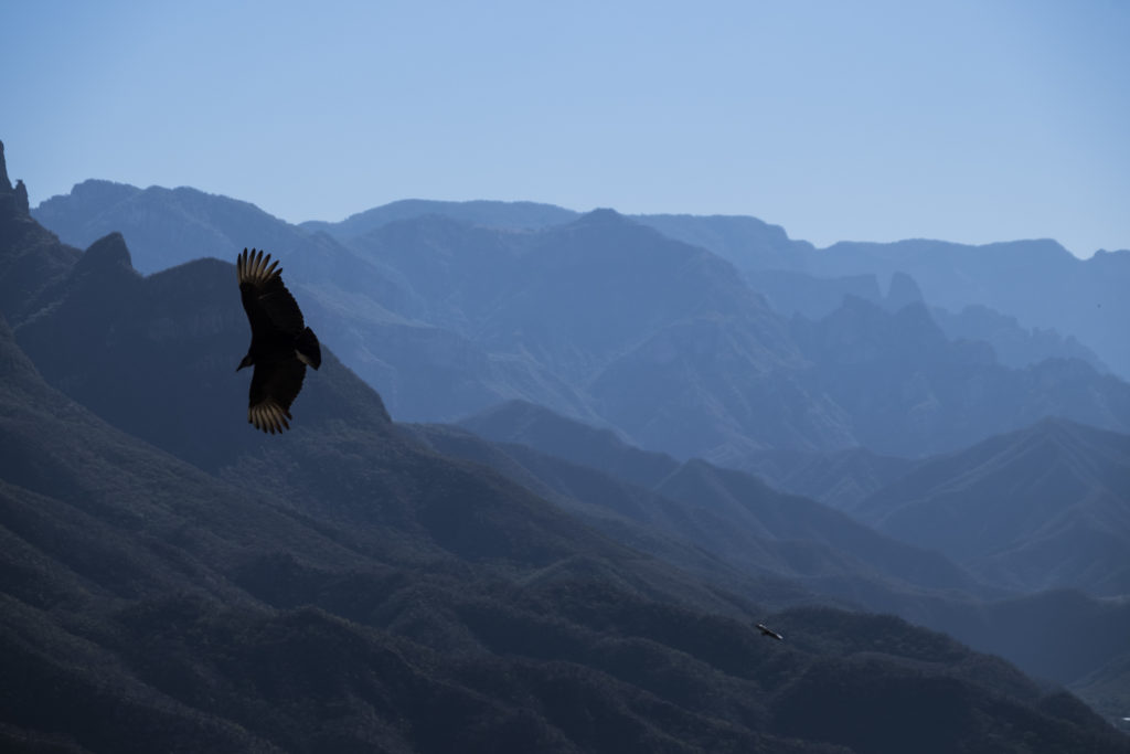
From there, our path laid southwest through Sierra Madre Occidental mountain range and the Copper Canyon. Four times as large and twice as the Grand Canyon, it was along our route to the South.
There was surprisingly little information we were able to find about it online, particularly for DYI travelers, so we figured that we’ll sort out the details as we get closer to it.
We arrived to Creel – a small town that’s considered to be the gateway to the canyon- on Wednesday at dusk and the atmosphere turned a tad ominous as it got darker. On the approach to town and within the town itself, a convoy of military pick up trucks with technicals and ski-mask clad soldiers standing in the rear would roll by occasionally patrolling the area.
Within the town themselves, the majority of the vehicles traversed with all of their windows tinted fully black while keeping their speed to an uncharacteristically low 30 km/h speed as they went through town. Everyone was moving at a slow and purposeful pace.
As it was getting dark, we found a small hotel with a secure parking, dropped off the vehicle, grabbed dinner nearby, and called it a night – wondering about the day that lay ahead and where we were.
The Consultation
At nine in the morning, we sat in a little travel agency in Creel, with its doors open and the early morning sun shining through the door into the dark interior. Due to the high altitude, the air still felt cool in the morning from the night before. Outside the door was the town’s main commercial street, with locals going on about their business, an occasional stray dog moving from one sun-lit spot into another, and the shops starting to open for customers. Whatever triggered the previous’ nights off-sense was no longer there.
Opposite us sat Gustavo, one of the guides working for the agency. He was friendly and smiling as he welcomed us to the office. Over the past few years, the tourism in the area has slowed down due to safety concerns, so he had the time to chat and address numerous questions we threw at him.
“You want to know the way to the bottom of the Canyon?”, he started as he laid out the map of the area on the table. “How’s his driving skills?” he looked first at me and then at Susan, waiting for a response. Satisfied with her reply, he continued.
“If you’re looking to go down to Urique”, which was our intended destination, “I suggest that you make sure that your vehicle has good brakes and tires, as it’s a steep, unpaved road all downhill. I suggest that you stay at least one way in Urique, as the road the next day on the way out will get tough. In part because of the condition, but also as it’s mainly unmarked and difficult to figure out how where to go, so it’s really better to have a local guide with you.”
Unfortunately, the guide wasn’t in the budget, so we’d have to rely on the all-knowing skills of Garmin and Google Maps, along with the map he provided us.
As we continued to chat, we asked him about the safety issues downhill. “Well… unless you’re working for the cartel, you should be fine,” he responded after a thoughtful pause. “You may come across some people, but the tourists are typically fine. I just had a couple of other tourists down there a week or two ago and they had a great time,” he reassured us.
We lingered in his office a bit longer, enjoying the comfort and familiarity, but as the daylight was limited, we said our goodbyes and headed to the car to leave Creel.

Going In Deep
Shortly after Creel was behind us, the two-lane tarmac road disappeared and was replaced by a one-lane dirt road that was covered by rocks and small boulders that we cautiously navigated between. As we started at the top of the canyon and went down, we were surrounded by the mountain on one side and the steep fall off on the other side that was occasionally masked by cacti and other plants.
We were traveling slowly as every once in a while, we’d have to veer off to the side as a fully loaded truck from the local copper mine would try to pass us through, leaving a cloud of dust as they’d do it. Each time, the road would seem too narrow to let both vehicles pass but eventually each party would inch through past each other and be on their way again.
Unlike the Grand Canyon to the North, Copper Canyon actually consists of seven major canyons over a tremendous land mass. As another overlander correctly noted, “with the Grand Canyon, you can take in a huge view all at once and feel like you got most of the experience, whereas with the Copper Canyons, the views tend to be much subtler and reveal yourself slowly as you get in further and further into the interior.”
Incidentally, the canyons are also home to the indigenous Tarahumara people, who are internationally known for their practically superhuman running abilities and incredibly good health. They’ve been made somewhat famous by a book that created a lot of noise in the running community – Born to Run.
The first day ended with us venturing deep into the canyon towards the village of Urique that lay at the bottom. Urique is a small village of just over a thousand inhabitants, lying quietly deep in the canyon to the very bottom of the Urique River flowing from the village. Descending from the rim of the canyon towards the bottom, the temperatures shifted from low 60s to low 80s – and the climate changed from alpine to sub tropical – the perfect weather for a night of camping.


Getting Out
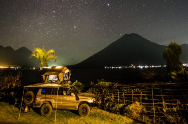
We spent the night in the only campground we found in the village – a small patch of land near one of the resident’s private garden.
As we woke up and got ready, we felt accomplished – feeling that the most challenging route was already behind us. After a leisure morning, we packed up and got ready to get a move on. To get out of the Copper Canyon, we had to head further West towards the town of Choix which would be the first significant population point, where we could refill on gas and get on the road that would eventually lead to Mexico City.
As we plugged in our coordinates for the destination that was about a 100 miles away, the GPS showed a surprising 6 to 7 hour journey. We joked among ourselves that surely we should be able to cover such measly distance in a more reasonable period of time and began the drive out of the canyon.
The route ended up fully devoid of other private cars and as the sun moved across the sky, even the flow of trucks from the mine slowed until it fully dissappeared and we went for a couple of hours with no other cars in sight. The going was slow due numerous mountain passes that we were crossing on the way.

Albeit slow, we were making progress towards the destination. About 40 kilometers away from the destination, as the sun was beginning to set, we came up an abrupt stop.
In the middle of the road, there was a wire fence blocking the passage. It completely stopped us in our tracks, as there was no way to drive or even walk around it.
With Google Maps showing the only path straight through it and the prospect of returning several hours backwards for an alternative route seemed particularly unappetizing, we stopped to mull over our options. The “low gas” light started to blink, although it wasn’t a big issue as we still had 15 gallons in reserves. More importantly, going back was a really tough option to consider as the daylight was almost gone and no clear alternative route was available.
As we stood outside the car, Susan called me over to show me something. As I turned, she was nudging the fence from a side and was about to say “look, you can open it right here”, as the entire fence suddenly collapsed on the road. A short nudge was apparently all it took to create a passage forward, albeit with some unpredictability as to what lay ahead.

Given that the end destination seemed so close and the prospect of going back several hours so unattractive, the decision virtually made itself and we headed further down. Although the road has deteriorated even further with potholes and boulders growing in size and occasionally requiring to get out of the car to check the path forward, the Land Cruiser held like a champ and pushed on through with its lights illuminating the way.
Slowly, the kilometers kept ticking away and about 45 minutes later, lights started to show in the distance. Before we knew it, the road has spit us out in a small village just a few kilometers away from town and a short period later, our tires hit the tarmac for the first time in 30 hours. Almost immediately, the entire experience felt surreal and as if it almost never happened.
We collectively released a sigh of relief and set our course to the final destination. We now knew exactly what the other travelers before us have meant when he said that the true Copper Canyons reveal themselves slowly until you can fully appreciate them.


2 Responses
Mysterious admirer
nice post, Boriskus. just got a chance to read and eagerly awaiting the next one. (refreshed the site like 100 times and still nothing….) AAAAHHHH. I needs more!
EdM
Боренька, Сюзан, спасибо, очень интересно. Так реалистично всё описанно. Чувствую, как будто путешествую с вами, сидя на заднем сиденье. Не мешаю:-) Аж дух захватывает 🙂 I’m just curious how you guys making decision where to go next morning? What to see? What kind of info affects your decisions? Any contacts with locals (beside that little tour agency)? Actually, any your observation is extremely interesting like we said in the past “мир глазами Сенкевича» 🙂 Осторожно, and have safe and enjoyable travel!